
30th Anniversary Post: Was GFE land once a quarry?
/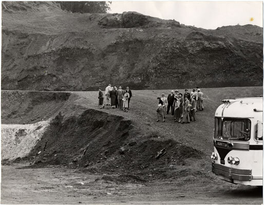
Was GFE a quarry? This is the photo that piqued our interest in this topic. Photo credit: AAF-0615 SAN FRANCISCO HISTORY CENTER, SAN FRANCISCO PUBLIC LIBRARY
In our quest for historical information on the land GFE occupies, the first photo (above), from October 11th, 1951, courtesy of San Francisco Public Library’s photo collection, got us curious -- was GFE once a quarry? The photo’s accompanying text reads: "INSPECTION TRIP--Members of the City's Planning and Housing Association survey a quarry at Seventh Ave. and Lawton St., one of several inspected yesterday in a tour designed to see if such quarrying is ruining housing sites. The group decided it was in some cases. The City Planning Commission is considering a proposal to prohibit digging quarries in San Francisco residential areas. The commission yesterday toured the city's 'interior greenbelt', a stretch of wooded acres through Sutro Forest, Twin Peaks, Glen Park and on to McLaren Park and Candlestick Point, to see if quarrying is jeopardizing prospective residential regions. The San Francisco Planning & Housing Association, sponsoring the tour, asked the commission to approve an ordinance to restrict quarrying. Such an ordinance is now in effect in San Mateo, Los Angeles and Oakland, the association said. The areas covered, the association declared, could provide homes for about 18,000 persons and could still maintain their natural beauty if quarrying is halted now."
We snooped a bit more and found this second photo (below), circa 1958 and courtesy of the Western Neighborhoods Project, which shows what indeed looks like a quarry, and was called Harvey’s Quarry in the photo’s caption. The arrow points to the base of this disturbed area, where GFE is now. We attempted to find more information online about Harvey’s Quarry, to no avail (at least not yet!).

The photo’s accompanying information on the Western Neighborhoods Project reads, “View NE from Pacheco St. near Funston Ave; looking northeast to Inner Sunset, Golden Gate Park, Mt. Sutro, and Harvey's Quarry.” Photo credit: Western Neighborhoods Project - wnp28.3733
Down the rabbit hole even further we found two aerial photos, courtesy of the David Rumsey Map Collection, from August 1938 and August 1948, that show the GFE land, indicated by arrows. These seem to indicate that the land appears to have just escaped being quarried. What we don’t know yet was how long Harvey’s Quarry existed, and if the GFE land ever had anything to do with it. We do know from the aerial photos that Warren Drive, on GFE’s southern border, and Locksley Avenue, on GFE’s eastern border, were not paved roads yet in 1948. So, some mysteries solved, others still unanswered!

An aerial view of the Inner Sunset area where GFE is located from August 27th, 1938. Despite all the nearby development, the GFE plot of land appears to be relatively untouched. Harvey’s Quarry may be in its early stages here, to the right of the GFE land. Photo credit: Cartography Associates / David Rumsey Map Collection

This photo was shot almost exactly ten years after the above photo, on August 15th, 1948. Harvey’s Quarry is much bigger here, but GFE still appears mostly undisturbed. What is now Locksley Avenue (bordering GFE to the east, to the right of the GFE land here) was a dirt road into the quarry. Photo credit: Cartography Associates / David Rumsey Map Collection